
As a doctoral researcher in the Imaging Science Department at the Rochester Institute of Technology, I specialize in bridging the gap between advanced remote sensing and the critical humanitarian need for safer land mine clearance. My work focuses on integrating multisensor drone platforms with artificial intelligence to address a global crisis where, in 2024 alone, over 6,000 people were killed or injured by these hidden hazards. By developing standardized benchmark datasets and uncertainty-aware AI models, we are creating the technical foundation necessary to transform demining from a slow, high-risk manual task into a rapid and reliable aerial operation.
Manual demining relies on probing and ground-based detectors that struggle with plastic mines or mineralized soil. How do environmental factors like wet terrain or heavy vegetation impact current detection accuracy, and why is the transition to drone-based aerial systems necessary for large-scale recovery?
Traditional ground-based methods are hindered by the physical properties of the earth itself, as wet terrain can severely degrade the performance of ground-penetrating radar, while mineral-rich soils create “noise” that masks the signal of low-metal or plastic mines. Vegetation acts as a physical barrier for manual probes and obscures the vision of deminers, making the process incredibly slow and resource-intensive. In 2024, demining operations successfully removed 105,640 mines, but given the massive scale of deployment in regions like Ukraine, these manual efforts simply cannot keep pace with the growing threat. Transitioning to drone-based systems allows us to survey hazardous areas approximately ten times faster than ground teams while completely removing the human operator from the immediate blast zone.
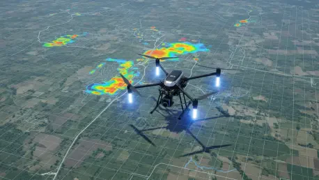
Aerial surveys use a mix of thermal, hyperspectral, and magnetic sensors to identify hidden objects. How do these sensors complement each other when dealing with camouflaged surface mines, and what specific signatures allow you to differentiate a mine from natural debris?
No single sensor is a silver bullet, so we use a “multisensor fusion” approach where different wavelengths of light and physical properties tell a complete story. For instance, an RGB camera captures the basic visual shape of a mine, but if that mine is camouflaged, a thermal sensor can detect the minute temperature differences between the synthetic casing and the surrounding soil. Hyperspectral and multispectral sensors go even further by identifying the unique chemical signatures of materials like plastic or treated metal that don’t occur naturally in the wild. By layering this data with magnetometers that find metallic fuses and LiDAR that maps subtle surface disturbances, we can filter out natural debris and focus on high-probability targets with much higher confidence.
Drone-mounted systems can survey areas ten times faster than ground teams while keeping personnel at a safe distance. What are the logistical steps involved in deploying these drones in a post-conflict zone, and how do you ensure the collected data is georeferenced with precision?
Deploying in a post-conflict zone requires a rigorous flight plan that accounts for varying altitudes and sensor types, often starting with high-altitude reconnaissance before moving to lower, high-resolution sweeps. To ensure the data is actionable for deminers on the ground, we use GPS base stations to provide centimeter-level accuracy for every pixel of data we collect. In our controlled tests, such as those in Oklahoma, we georeferenced over 140 inert targets to ensure that the “ground truth”—the exact known position of a mine—matches our digital map perfectly. This precision is vital because once the drone flight is over, a technician needs to be able to return to that exact coordinate to safely neutralize the threat.
Publicly available benchmark datasets for training detection models are currently scarce. How did your collaborations in Oklahoma and Belgium help standardize this data, and what challenges did you face when simulating the realistic aerial dispersal of mine replicas across varied terrains?
Our collaborations were designed to fill a massive void in the research community by creating the first truly comprehensive, open-access datasets for mine detection. In Oklahoma, we worked with the Demining Research Community to capture data on 140 targets using everything from synthetic-aperture radar to electromagnetic induction metal detectors. In Belgium, we stepped up the complexity by deploying over 110 replicas of PFM-1 mines across diverse vegetation to simulate realistic “scatterable” minefields that are dropped from the air. The biggest challenge was ensuring the replicas were distributed realistically while still precisely surveying their locations with GPS, providing the high-quality labels that AI researchers need to train their algorithms effectively.
A single false negative in land mine detection can be fatal for civilians. How does incorporating “uncertainty estimation” into AI models change how demining operators interact with the technology, and what happens when a system identifies an object it cannot confidently classify?
In high-stakes environments like a minefield, an AI that is “wrong but confident” is the most dangerous tool a deminer could have. My research incorporates uncertainty estimation, which essentially gives the AI a way to say, “I see something, but I am not sure what it is.” When the system identifies a target but assigns it a high uncertainty score due to noise or heavy vegetation, it flags that area for human intervention or a closer look with a different sensor. This changes the operator’s role from blindly trusting a computer’s “yes/no” to acting as a strategic supervisor who investigates the most ambiguous and dangerous locations with extra caution.
Land mine clearance is often a slow, resource-intensive process that leaves farmers and children at risk for decades. Beyond the technical algorithms, how can open-access data and multisensor fusion specifically help communities reclaim their land and rebuild their local economies more quickly?
The ultimate goal of this technology is to restore the rhythm of daily life by returning safe land to the people who need it most. When we release open-access data, we enable developers worldwide to create faster, cheaper detection tools that humanitarian organizations can deploy in months rather than decades. By speeding up the survey process tenfold, we can clear agricultural fields more rapidly, allowing farmers to plant crops and children to walk to school without the constant shadow of a tragedy that claims thousands of lives annually. It is about using science to turn a landscape of fear back into a productive environment where local economies can finally begin to recover.
What is your forecast for the future of drone-assisted demining?
I believe we are moving toward a future where “swarms” of specialized drones will autonomously map entire provinces, using onboard AI to fuse multisensor data in real-time. We will see a shift away from isolated sensor tests toward integrated platforms where thermal, magnetic, and hyperspectral data are processed instantly to provide demining teams with a comprehensive, prioritized map of hazards. As these AI models become more adept at handling uncertainty and as open-source datasets grow, the cost of clearing a square meter of land will plummet. Ultimately, this technology will make manual probing a rare last resort, ensuring that the next generation grows up in a world where the earth beneath their feet is no longer a hidden weapon.