
What if a silent, invisible threat could be detected long before it endangers communities hundreds of miles away from a wildfire’s flames? Wildfire smoke, a pervasive hazard that often outstrips the reach of the fire itself, impacts air quality and public health on a massive scale, affecting millions annually with respiratory issues and reduced visibility. With the urgency to track and predict smoke dispersion at an all-time high, a groundbreaking solution has emerged: AI-equipped drones that promise to revolutionize how smoke plumes are monitored and managed, offering hope in the face of escalating wildfire crises.
The significance of this innovation cannot be overstated. As wildfires grow in frequency and intensity due to climate change and human activities, traditional methods of smoke tracking—often reliant on outdated models or expensive satellite imagery—fall short in delivering real-time, actionable data. AI drones, developed through cutting-edge research at the University of Minnesota Twin Cities, present a cost-effective, high-resolution alternative. This technology not only enhances public safety by improving air quality forecasts but also equips wildfire management teams with tools to respond faster and more effectively, potentially saving lives and protecting ecosystems.
Could Smoke Detection Happen Before Disaster Strikes?
Picture a small prescribed burn spiraling out of control, sending a massive smoke plume drifting toward unsuspecting towns. Without advanced warning, residents and officials remain unaware until air quality plummets, triggering health emergencies. This scenario underscores a critical gap in current systems, where smoke often goes undetected until it’s too late to act. The concept of preempting such dangers through technology offers a promising prospect for communities at risk.
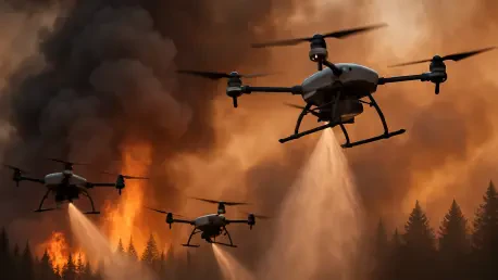
AI drones stand poised to fill this void by providing real-time surveillance of smoke plumes. Equipped with onboard sensors and computer vision, these autonomous aerial robots can navigate directly into hazardous zones, capturing data that was previously inaccessible. This capability marks a shift from reactive to proactive strategies, ensuring that threats are identified and addressed before they impact distant populations.
Why Is Smoke Tracking an Escalating Emergency?
The challenge of wildfire smoke has intensified in recent years, driven by a surge in fire incidents linked to both natural causes and human practices. A striking statistic from the Associated Press reveals that, over a decade, 43 wildfires emerged from 50,000 prescribed burns, highlighting the unpredictable nature of even controlled fires. As smoke particles travel vast distances, they degrade air quality far beyond the fire’s origin, posing health risks to millions.
Current tools for analyzing smoke dispersion face significant limitations. Traditional simulation models often lack precision, while satellite systems, though useful, come with high costs and delayed data delivery. These shortcomings hinder timely responses, leaving communities vulnerable to sudden air quality declines and exacerbating environmental damage. The need for a more agile, accurate solution has become a pressing priority for public safety and ecological stability.
How Do AI Drones Redefine Smoke Analysis?
At the forefront of this technological revolution are AI drones, engineered to tackle the complexities of smoke plume tracking with unprecedented detail. Research from the University of Minnesota Twin Cities showcases autonomous drone swarms that use advanced sensors to gather data directly within smoke clouds. These drones create 3D reconstructions of plumes, offering insights into particle behavior and flow patterns that traditional methods cannot match.
Specific innovations elevate this technology further. Techniques like Digital Inline Holography enable precise characterization of smoke particles, while fixed-wing VTOL drones extend surveillance range with over an hour of flight time. Compared to costly satellite systems, these drones provide high-resolution data at a fraction of the expense, making large-scale monitoring feasible for government and environmental agencies aiming to protect vulnerable areas.
This approach directly addresses the gaps in existing systems. By delivering real-time, granular information, AI drones empower officials to predict smoke spread with greater accuracy, paving the way for faster interventions. The potential to scale this technology across regions prone to wildfires marks a significant leap toward comprehensive smoke management.
What Do Experts Say About This Breakthrough?
Insights from the University of Minnesota team underscore the transformative potential of AI drones. Professor Jiarong Hong emphasizes the critical role of early detection, stating, “The sooner you can see the fire, the faster you can respond.” This perspective highlights how immediate data collection can shift the dynamics of wildfire response from mitigation to prevention.
Graduate research assistant Nikil Krishnakumar adds a practical dimension, noting the cost-effectiveness of the technology for expansive data gathering. “This approach allows for large-scale monitoring without the prohibitive costs of other systems,” he explains. Such affordability could democratize access to advanced smoke tracking, enabling broader adoption by resource-strapped organizations.
A compelling test flight anecdote further illustrates this potential. During a recent trial, a swarm of drones successfully mapped a smoke plume in real time, providing data that aligned closely with ground observations. Published findings in Science of the Total Environment lend scientific weight to these achievements, reinforcing the credibility of this research as a game-changer in environmental monitoring.
What Practical Benefits Do AI Drones Offer Communities?
Deploying AI drones offers tangible solutions for safeguarding populations against wildfire smoke. A clear implementation strategy involves using drone swarms to monitor active fires and prescribed burns, delivering instant updates on plume movement. This data can inform air quality alerts, ensuring residents receive timely warnings to take protective measures like staying indoors or wearing masks.
Beyond immediate tracking, the 3D models generated by drones enhance forecasting models, allowing meteorologists and health officials to predict smoke impacts with greater precision. Integration with wildfire containment strategies also means faster suppression efforts, as managers gain a clearer picture of fire and smoke dynamics. Such coordination could reduce the scale of damage during critical events.
The versatility of this technology extends its value further. Applications beyond wildfires, such as monitoring sandstorms or volcanic ash clouds, demonstrate its adaptability to diverse environmental threats. For government bodies and conservation groups, investing in AI drones represents a multi-purpose toolset, amplifying their capacity to protect both human and natural resources across varied scenarios.
Reflecting on a Path Forward
Looking back, the journey to harness AI drones for wildfire smoke tracking revealed a profound shift in how environmental threats are approached. The collaboration of cutting-edge technology with urgent public needs has yielded a tool that once seemed futuristic but has become a reality through dedicated research and innovation. Each test flight and data point collected has built a foundation for safer, more informed communities.
Moving ahead, the focus should turn to scaling this technology through partnerships between universities, governments, and private sectors. Prioritizing funding for widespread drone deployment in high-risk zones could ensure that no community remains unprepared for smoke hazards. Additionally, expanding training programs for local agencies to operate and interpret drone data would maximize impact. As new challenges emerge, continuous refinement of this technology promises to keep pace, offering a beacon of resilience against the growing specter of wildfires.