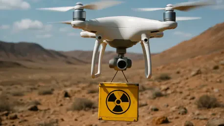

In a world where threats can be invisible and microscopic, the speed and precision of our response are paramount. The recent incident in Australia, where a tiny but potent cesium capsule was lost, highlighted the limitations of traditional search methods. It’s in this high-stakes environment that Oscar Vail, a technology expert at the forefront of robotics and autonomous systems, is pioneering solutions that could redefine emergency response. His work on highly automated unmanned aerial systems (UAS) for detecting radioactive sources is not just an academic exercise; it’s a practical tool that can turn a days-long search into a matter of minutes. Today, we’ll delve into the mechanics of this groundbreaking technology, exploring how these drones intelligently hunt for threats, the sophisticated fusion of sensor data that guides them, and how this information is translated into actionable intelligence for responders on the ground. We will also look ahead to the next frontier: tracking multiple and even moving radioactive targets.
When a small radioactive source like the cesium capsule in Australia was lost, the search took days. How does your automated UAS technology reduce this search time to mere minutes? Could you walk us through the practical, step-by-step advantages it offers over a ground team with handheld detectors?
The situation in Australia is the perfect illustration of the problem we’re solving. A ground team, even a large one, is limited by human speed and the narrow scope of handheld detectors. They have to methodically sweep vast areas on foot, which is painstakingly slow and exhausting. Our UAS completely changes the paradigm. Instead of a linear ground search, we have an aerial platform that can cover the entire target area in a fraction of the time. The drone is launched and in just a few minutes, it can accomplish what might take a ground team all day. It’s not just about speed, but efficiency; our system can autonomously identify and localize a source down to within a few meters. This means we can direct emergency services to the precise location of the threat, saving critical time and reducing their exposure to potential harm.
Your system uses a two-phase process involving exploration and a targeted search. What specific radiation data or threshold triggers the switch from the fixed flight pattern to the adaptive search mode? Could you elaborate on how the onboard computer then calculates the most probable location of the source?
The transition between phases is a critical, automated decision point. During the initial exploration phase, the UAS flies a pre-planned, fixed pattern while its gamma detector constantly measures the ambient radiation. We’re essentially establishing a baseline. The trigger to switch to the adaptive search mode is any statistically significant deviation from this natural background radiation. It’s not a single, fixed number, but a dynamic threshold that alerts the system to an anomaly. Once that trigger is hit, the real intelligence of the system kicks in. The onboard computer begins employing stochastic methods—a sophisticated way of saying it calculates probabilities. It takes all the radiation data gathered so far, combines it with the drone’s precise location from the IMU, and starts building a probability map of where the source is most likely to be. It then independently generates new waypoints, directing the drone to fly to the areas of highest probability to gather more data and continuously refine its estimate until it pinpoints the location.
The drone carries a suite of sensors, including cameras, an IMU, and a gamma detector. How do you fuse the data from these different sources in real-time? For example, can you share an instance where visual data from the cameras helped refine the location pinpointed by the radiation sensor?
Sensor fusion is the heart of the system; it’s what turns raw data into true situational awareness. The gamma detector tells us what and where the radiation is, and the Inertial Measurement Unit, or IMU, provides the drone’s precise 3D position and orientation, which is crucial for accurately georeferencing every radiation reading on a map. The cameras add the essential layer of context. For instance, the gamma detector might lead the drone to a specific coordinate with high radiation levels in an industrial park. The radiation reading alone doesn’t tell you the cause. But when the live feed from the electro-optical or infrared camera shows a damaged container or a specific piece of equipment at that exact spot, the operator on the ground immediately understands the physical nature of the source. The system can even automatically detect objects like vehicles or buildings and overlay them on the map, giving responders a complete operational picture before they ever set foot in the area.
Visualizing the data is key for operators. What is the difference between the spatial heat map and the probability map your system generates? Please describe how an emergency response commander would use both of these tools on the ground to make critical decisions during a CBRNE incident.
Both maps are crucial, but they serve different purposes for a commander on the ground. The spatial heat map is the most intuitive visual—it paints a picture of the radiation levels across the entire area the drone has flown over. Think of it like a weather radar map for radiation, with colors indicating intensity. A commander would use this for immediate safety decisions: establishing hot zones, setting up cordons, and planning safe entry and exit routes for their teams to minimize exposure. The probability map is more of an analytical tool used during the search. It shows the calculated likelihood of the source being in any given grid cell. A commander would watch this map evolve in real-time as the drone hones in on the target. The cell with the highest probability is the drone’s primary target, and seeing that probability increase and the location narrow down gives the commander confidence in where to deploy recovery assets once the search is complete.
Your follow-up SLEIPNIR project aims to increase airspeed and track multiple or even moving radioactive sources. What are the main technical challenges in tracking a moving target, and what advancements in sensor fusion or predictive algorithms will be necessary to overcome them successfully?
Moving from a static source to a dynamic one is a quantum leap in complexity. With a stationary object, you’re essentially solving a puzzle with a fixed solution. When the source is moving, the puzzle is constantly changing. The primary challenge is that by the time you take a measurement, fly to a new spot, and take another, the target has moved again. Your data is always slightly out of date. To overcome this, we can’t just react to data; we have to predict it. This will require significant advancements in our algorithms. We’ll need to develop predictive models that can estimate the target’s trajectory and speed based on a sequence of radiation measurements. This means fusing the sensor data over time to build a motion profile, allowing the drone to anticipate where the source is going to be and fly there, rather than chasing where it was. It’s a challenge that will push the boundaries of real-time data processing and autonomous decision-making.
What is your forecast for the use of autonomous systems in CBRNE response?
I believe we are on the cusp of a major transformation. What we’re doing now with single drones localizing static sources is just the beginning. I foresee a future where teams of autonomous systems—both aerial drones and ground robots—work collaboratively. Imagine a scenario where a fleet of drones performs the initial wide-area search, and once they detect multiple sources, they autonomously assign ground robots to approach, visually inspect, and even handle the material. These systems will be fully integrated into the emergency response network, feeding real-time data not just to a single operator, but to a common operational picture accessible by every stakeholder. This will dramatically increase the safety of first responders, accelerate our ability to contain threats, and ultimately, make our communities safer in the face of these invisible dangers. The human will always be in command, but their tools will be far more powerful and intelligent.