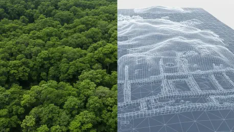

The landscape beneath our feet often holds secrets that remain invisible to the naked eye, hidden by centuries of sediment, dense forests, and the relentless expansion of modern urban development. For generations, archaeologists relied on physical surveys and traditional maps to locate historical remnants, but the scale of modern data has far outpaced the capacity for manual human review. Currently, the integration of deep learning into landscape archaeology is transforming how researchers identify these buried historical traces before they are lost forever to time. A sophisticated new tool known as Automatic Detection of Archaeological Features has emerged as a high-precision solution to the inherent limitations of manual data analysis. By processing airborne laser-scanning data, this artificial intelligence assists scientists in seeing through dense vegetation and complex terrain to spot subtle depressions or elevations that indicate ancient activity. This shift allows for an objective and efficient approach to global preservation.
Bridging the Gap Between Technology and Discovery
Addressing the Data Bottleneck: Solving the Information Overload
The widespread adoption of Light Detection and Ranging, commonly referred to as LiDAR technology, has completely revolutionized the field by providing high-resolution maps of the Earth’s surface that strip away tree cover. However, this technological success has inadvertently created a massive data bottleneck that threatens to slow down the pace of discovery across the globe. Human analysts, despite their immense expertise and dedication, face significant physical limitations and cognitive fatigue when scanning thousands of square miles of digital terrain. The sheer volume of information generated by modern aerial surveys makes it nearly impossible for small teams to review every meter of ground with the same level of scrutiny. Furthermore, subjective bias often leads different researchers to interpret the same data in conflicting ways, which can result in inconsistent records and missed opportunities to protect vulnerable heritage sites from modern construction projects or environmental erosion.
To solve this persistent problem of information overload, the development of the Automatic Detection of Archaeological Features system provides a standardized method for filtering vast quantities of geospatial data. This tool acts as an initial screening layer, flagging potential points of interest for human experts to verify later, which drastically reduces the amount of time spent on monotonous manual scanning. By automating the identification of shapes that match known historical patterns, the system ensures that analysts can focus their energy on the most promising leads rather than laboring over empty terrain. This partnership between human intuition and machine efficiency represents the current standard for large-scale archaeological research in 2026. As the demand for rapid land assessments grows due to expanding infrastructure, having a reliable system to process high-resolution imagery becomes essential for balancing development with the preservation of ancient cultural landscapes.
Collaborative Development: Bridging Computer Science and Archaeology
The creation of the Automatic Detection of Archaeological Features platform was the result of an ambitious international collaboration involving the Slovenian Academy of Sciences and Arts and the Discovery Programme in Ireland. This partnership brought together experts from Bias Variance Labs to bridge the gap between advanced computer science and the requirements of field archaeology. Unlike generic image recognition software, this tool was built specifically to handle the complexities of historical features that have been weathered and eroded over thousands of years. The team recognized that archaeological traces are often barely perceptible, appearing only as faint outlines or minor changes in surface elevation that are easily confused with natural geological formations. By combining archaeological expertise with cutting-edge machine learning, the collaborators developed a system that understands the specific morphological characteristics of ancient settlements, providing a level of sensitivity that generic algorithms typically lack.
One of the primary goals of this collaborative effort was to ensure that the system could identify a wide variety of features, ranging from large enclosure sites to the smallest circular depressions known as ringforts. These structures are integral to understanding the social and economic history of regions like Ireland and Slovenia, yet they are often located in remote areas or under dense forest canopies where traditional aerial photography is useless. The tool was designed to be adaptable, allowing it to work across different terrain types and vegetation levels without losing its accuracy or reliability. This flexibility is vital because the appearance of a monument can change significantly depending on the local soil composition and the degree of agricultural disturbance in the area. By creating a unified framework for detection, the researchers have empowered the archaeological community to conduct comprehensive surveys that were previously thought to be too labor-intensive for smaller national agencies.
Decoding the Digital Landscape
Advanced Machine Learning: The Dual Toolkit Architecture
At the technical core of this innovation lies a sophisticated pipeline that utilizes a dual-toolkit approach to transform raw geodata into actionable intelligence for researchers. The process begins with the Relief Visualisation Toolbox, which converts raw LiDAR elevation points into high-quality visual representations that highlight the subtle contours of the ground. These visualizations are then processed by the Artificial Intelligence Toolbox for Earth Observation, which employs advanced neural network architectures to scan for human-made patterns. Specifically, the system utilizes High-Resolution Net, or HRNet, for detailed pixel classification, allowing it to segment different parts of the landscape with remarkable precision. Additionally, the integration of the Faster R-CNN model enables the software to identify and localize specific objects of interest within the larger map. This combination of semantic segmentation ensures that the AI can differentiate between a natural hill and a man-made mound.
To achieve such high levels of accuracy, the machine learning models underwent rigorous training using an extensive dataset consisting of over 10,700 confirmed monuments located throughout Ireland. By feeding the AI more than 200 individual datasets containing known archaeological sites, researchers allowed the system to learn the intricate textures and geometric shapes associated with ancient human activity. This training phase was crucial for teaching the neural networks how to ignore modern agricultural features, such as drainage ditches and field boundaries, which often mimic the appearance of historical earthworks. The AI was taught to recognize the specific signature of a monument, even when that signature was partially obscured or damaged by centuries of farming. This massive library of confirmed data serves as the foundation for the tool’s predictive capabilities, enabling it to apply learned patterns to new territories with a degree of confidence that matches traditional manual methods.
Strategic Validation: Improving Accuracy and Global Accessibility
The practical effectiveness of this automated approach was recently put to the test during a significant project south of Limerick, where the system achieved an impressive 84% recall rate for identifying known archaeological sites. This high level of performance confirmed that the AI is capable of matching the accuracy of experienced analysts while working at a much higher speed. More impressively, the tool identified 116 potential new features that had been completely overlooked during all previous manual surveys of the region. These new discoveries highlight the system’s ability to perceive faint topographic signals that are often missed by tired human eyes during long hours of data review. While these identified locations still require final ground verification by field teams, the ability to generate a highly accurate list of candidate sites provides an invaluable resource for land-use planners and heritage managers who must decide which areas require the highest levels of protection.
Archaeologists finalized the release of the source code and training models to the public, ensuring that this technology remained accessible for researchers across the globe. This transition toward open-source tools allowed smaller institutions to implement advanced detection capabilities without the need for prohibitive licensing fees or specialized hardware. By removing the variance associated with individual human analysts, the research community established a more consistent and objective standard for recording the world’s cultural heritage. These advancements paved the way for future applications in diverse environments, from the dense rainforests of Central America to the arid deserts of the Middle East. Developers integrated feedback loops that allowed the system to learn from every verified discovery, continuously improving its precision. Ultimately, the implementation of these automated tools ensured that the remnants of the past were identified before modern expansion erased them.